ClimateSudan seasons are limited to only 2, Summer and Spring. IN the summer, on average, the temperature reaches anywhere from 38 degrees Celsius to 43 degrees Celsius. Mainly only in deserts it reaches 43 degrees Celsius and there gets lots of dust storms and little to no rain. the year average in Khartoum is 26.7 degrees Celsius. during the rainy season, which runs between Mid-June to September averaging 254 mm (10 inches) of rain.
Landforms and Natural ResourcesOn the Western side of Sudan, Darfur, meaning "Realm of Fur," one of the provinces, homes the Marrah Mountains. The Marrah mountains are volcanic massifs formed by dormant or dead volcanoes. the highest point is the Deriba Caldera. this point is a dormant volcano. Another mountain range is the Nuba Mountains, also known as the Nuba Hills. they are located in South Kordofam, a province of Sudan. Sudan's largest natural resource is petroleum. Sudan also has large deposits of chromium ore, copper, mica, iron, silver, gold and zinc.
|
VegetationNorthern Sudan is 1/3 Arid desert, it is part of the Sahara desert and receives very little rain. Khartoum, the capital, gets super hot, some rain, and wind that blows reddish-yellow sand. Central Sudan is a tropical like area, with rain and heat, but the farther go go south, the longer the rainy season lasts. So, in the southern part of Sudan, (Not South Sudan the country) is still very tropical, but with grasslands, marshlands, and rain forests. the rainy season last from 2 to 3 months.
95% of Sudan's agricultural products. 41.8 million acres are dedicated to arable, farming land to grow plants and food. to provide the wet, fertile land, 4.7 million acres are for irrigation uses, mainly using the Nile for the land. some of these exports and foods are: sesame, sugar cane, peanuts, dates, citrus fruits including: oranges, lemons and limes, yams (sweet potatoes), tomatoes, mangoes, coffee, tobacco, and cotton sudan's principal export. |
LocationSudan is the 3rd largest country in Africa, following Algeria and the Dominican Republic of the Congo. The total area of Sudan is 1,886,068 km2 Sudan is bordered on the countries of Egypt, Eritrea, Ethiopia and South Sudan. The Red Sea also lies along the North-East side of Sudan. Sudan's time zone is the East Africa Time Zone, which is UTC +3:00, so that is three hours ahead of the Greenwich time zone, or the Universal Time Zone.
Since Sudan is a very hot country, there aren't very many large, natural water ponds. the main two are the Nile river running North to South, and the Red Sea located in the North-East corner of Sudan. |
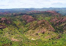
The Nuba Mountains In South Kordofam.
|
